


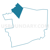
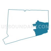
Lebanon 1 Voting District, New London County, Connecticut
About
Outline

Summary
| Unique Area Identifier | 550089 |
| Name | Lebanon 1 Voting District |
| County | New London County |
| State | Connecticut |
| Area (square miles) | 55.25 |
| Land Area (square miles) | 54.10 |
| Water Area (square miles) | 1.15 |
| % of Land Area | 97.91 |
| % of Water Area | 2.09 |
| Latitude of the Internal Point | 41.63295500 |
| Longtitude of the Internal Point | -72.24008960 |
Maps

Graphs
Select a template below for downloading or customizing gragh for Lebanon 1 Voting District, New London County, Connecticut


Neighbors
Neighoring Voting District (by Name) Neighboring Voting District on the Map
- Bozrah 1 Voting District, New London County, CT
- Colchester 3 Voting District, New London County, CT
- Columbia 1 Voting District, Tolland County, CT
- Franklin 1 Voting District, New London County, CT
- Hebron 1 Voting District, Tolland County, CT
- Salem 1 Voting District, New London County, CT
- Windham 1 Voting District, Windham County, CT
- Windham 3 Voting District, Windham County, CT
- Windham 5 Voting District, Windham County, CT
Top 10 Neighboring County Subdivision (by Population) Neighboring County Subdivision on the Map
- Windham town, Windham County, CT (25,268)
- Colchester town, New London County, CT (16,068)
- Hebron town, Tolland County, CT (9,686)
- Lebanon town, New London County, CT (7,308)
- Columbia town, Tolland County, CT (5,485)
- Salem town, New London County, CT (4,151)
- Bozrah town, New London County, CT (2,627)
- Franklin town, New London County, CT (1,922)
Top 10 Neighboring Place (by Population) Neighboring Place on the Map
Top 10 Neighboring Elementary School District (by Population) Neighboring Elementary School District on the Map
- Hebron School District, CT (9,686)
- Columbia School District, CT (5,485)
- Salem School District, CT (4,151)
- Bozrah School District, CT (2,627)
- Franklin School District, CT (1,922)
Top 10 Neighboring Secondary School District (by Population) Neighboring Secondary School District on the Map
Top 10 Neighboring Unified School District (by Population) Neighboring Unified School District on the Map
- Windham School District, CT (25,268)
- Colchester School District, CT (16,068)
- Lebanon School District, CT (7,308)
Top 10 Neighboring State Legislative District Lower Chamber (by Population) Neighboring State Legislative District Lower Chamber on the Map
- State House District 49, CT (25,268)
- State House District 48, CT (25,194)
- State House District 139, CT (24,449)
- State House District 55, CT (24,373)
- State House District 8, CT (23,861)
- State House District 37, CT (23,310)
Top 10 Neighboring State Legislative District Upper Chamber (by Population) Neighboring State Legislative District Upper Chamber on the Map
- State Senate District 29, CT (103,291)
- State Senate District 19, CT (100,189)
- State Senate District 33, CT (98,002)
- State Senate District 20, CT (96,786)
Top 10 Neighboring 111th Congressional District (by Population) Neighboring 111th Congressional District on the Map
Top 10 Neighboring Census Tract (by Population) Neighboring Census Tract on the Map
- Census Tract 8701, New London County, CT (7,308)
- Census Tract 8005, Windham County, CT (7,007)
- Census Tract 8003, Windham County, CT (6,430)
- Census Tract 8601, Tolland County, CT (5,485)
- Census Tract 7141.04, New London County, CT (5,105)
- Census Tract 5261.01, Tolland County, CT (4,630)
- Census Tract 7151, New London County, CT (4,151)
- Census Tract 8004, Windham County, CT (4,040)
- Census Tract 7131, New London County, CT (2,627)
- Census Tract 7121, New London County, CT (1,922)
Top 10 Neighboring 5-Digit ZIP Code Tabulation Area (by Population) Neighboring 5-Digit ZIP Code Tabulation Area on the Map
- 06226, CT (20,114)
- 06415, CT (16,857)
- 06249, CT (7,308)
- 06237, CT (5,492)
- 06420, CT (4,182)
- 06231, CT (4,083)
- 06334, CT (2,592)
- 06254, CT (1,922)
- 06266, CT (495)
- 06336, CT (84)